
Fire Mountain, Huo Yan Shan (火炎山) – A Hike With A View
Fire Mountain is one of Taiwan’s more popular hikes, and for good reason. Its shape and color are unique in Taiwan, and the views are not too difficult to hike to. Aptly named Fire Mountain because of the reddish jagged tips of the mountain, it’s recently gained new-found popularity since it opened to the public a few years ago.
Fire Mountain, also known as Huo Yan Shan or Flaming Mountain, is a nature reserve situated by the borders of Miaoli and Taichung. It used to be closed to the public to protect the endangered species, then opened to hikers with special permits, and now, after reconstruction and roping off dangerous areas, has been opened to all.
*Because it still is a nature reserve, PLEASE be wary of what you bring, and don’t leave anything on the trails.*
Quick Facts
- Huoyanshan is 614m above sea level.
- The hike takes 3 – 4 hours roundtrip total. We started the hike at 1:26pm and finished the round trip with time to take a couple photos, eat our lunch – and without rushing – at 4:13pm. Just under 3 hours!
- If however, you just want to see the peak, it should only take 2 hours round trip.
- It may get slippery, bring proper hiking shoes and hiking sticks.
- Don’t sit close to the edge. There have been a few deaths from people sitting too close for a photo and slipping down the gorge.
Starting The Hike
We started the hike close to the exit. Prepping our PBJ sandwiches for our celebratory lunch at the top, then headed out.


After almost accidentally running up the wrong way, we realized the entry to the hike was down the road. We quickly reversed and started the hike from the correct entrance. (If we had gone up it would have taken us about 2 – 3 hours to reach the peak.)
The hike started off with a couple stony steps, and after 10 minutes ended on a dusty uphill slope.

This is where a hiking stick and stable shoes come in handy. The slope while not too much of an incline was more slippery where sand/dust had settled.


A long dusty red road leading to another sign pointing us in the right direction.

The sign pointed to two different paths, naturally we picked the 0.5 and 2km long hike to get us to the peak and back. We had made it this far, gotta go all the way!

In just 20 minutes, it seemed like we were nearing the top of the mountain already. This part of the hike while absolutely breathtaking (partly because of the dust, but mostly the views), was also a little frightening. The tree roots looked like they were hanging on by their root hairs, we didn’t know how the tip was supporting all the people that were hiking this mountain daily.


The path took you along the ridges, with unobstructed views the entire way. Halfway up we met a family that told us to be careful as someone had fallen only a few months ago. News article here. I can’t stress enough how careful you should be!


The path would wind up and down along the ridge, some openings let you go closer to take in the views, while some paths would take you further into the mountain where the flooring was more stable.

Every few minutes, we would reach an opening and look out to see if we were closer to the peak, and at 2:03pm, we finally saw it!
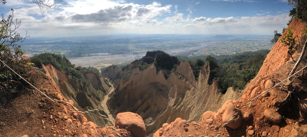
The Peak

A gorgeous canyon! (Pun intended). With Taiwan being such a wet country, it’s rare to see geological formations like this one, where the canyons have crumbled and land oxidized to form the deep red. We took a celebratory photo (I mean – you just have to), and continued along the path.


20 minutes from the popular viewpoint we reached another opening, but this time we didn’t see much of the dusty red mountain and only 360 views of the cities around us.

The Descent
As we descended, we had to hold onto our hats as the wind was incredibly strong up there. I read a blog post written in 2019 that talked about how it was almost too windy for a drone. If you’re hiking, a light jacket, or long-sleeved shirt might be recommended if you’re going to sit near the peak for a while.


A couple more steps made out of large rocks and sticks, with ropes to help pull yourself up, or support your weight on the way down. By now the trail was easy to follow, leading us towards a clearing in the woods were a couple groups had gathered to eat their lunch.
We continued following the path to the exit, thinking we were close to done. The dust cleared away and the trail became a long path lined with tall trees.

Then it cleared, and we thought we were even closer, but it was more downhill slope. At one point, the path turned into road and we saw houses and scooter. But it was still even more of a walk to the actual exit.


Finally after almost 40 min from where we started our exit, we made it back to the main road! We were tired, but the hike was incredible satisfying. The changing landscapes, weather, views, and ofcourse company, made it one of the better hikes I’ve been on.
Difficulty: 3/5
Views: 5/5
Uniqueness: 5/5
What To Bring
- Water bottle.
- Hiking Shoes.
- Long sleeved shirt to wear at the top.
- Gloves if you will be using the ropes to climb.
- A scarf to cover your mouth if dust is irritating to you.
- Camera or phone to take lots of pictures!
How To Get There:
Huoyanshan is easy to get to via car. You drive off the highway, park under it, and walk straight up to the entrance.
Other options are taking the train to Sanyi Railway Station, then walking 10 minutes to the entrance. If you’re coming from another city, you can book your HSR tickets using this 3-day HSR pass which gives you enough time to take you there and back if you decide to stay the night.
Starting Point and Parking:
Parking:
We were able to park under the highway. You’ll see many cars parked along this road which is right by the entrance of the hike. It was free during the weekends.
I’ve also completed the Dakeng Trail #4 in Taichung and recommend it to hikers looking for a challenging uphill battle on stairs.
Have you visited Huoyanshan? Leave your thoughts below!
Leave a Reply